Backpacking in the Lemhi Range, Idaho
"The act of driving your body, very occasionally, close to its limit of endurance is for some reason one of life's major satisfactions. And relaxing afterwards is one of life's most luxurious rewards."
One of the books I have been using to help me identify potential destinations in my new home state ("Backpacking Idaho" by Douglas Lorain) has this to say about the area: "To call the Lemhi Range 'remote' is a little like saying that the weather in Siberia can get a bit nippy. Hidden behind the already isolated Lost River Range, the Lemhis may be the least known significant mountain range in the lower 48 United States." It's located in the Salmon-Challis National Forest, but even their website had little information about the specific range. I ended up ordering the USFS 1:126,000 scale map, as it had the most useful information of any of the maps I was able to locate while planning the trip. (Yes, I am old-school. Even with amazing electronics and multiple map and navigation options on GPS and iPhone, I still take an old-fashioned magnetic compass and physical map with me).
The author described a 46-mile loop through the central part of these mountains, to which he assigned ratings on a scale of 1-10 for Scenery (8), Solitude (9), and difficulty (8). Despite the difficulty rating, I decided to tackle it anyway, because I didn't know where else to go, and I am an eternal optimist when it comes to my own capabilities.
I completed the trip during the period 21-29 June. For various reasons that I will describe, it turned out to be one of the hardest things I have done for a very long time. It was well worth the effort, but I'd rather not have to work quite so hard next time, thank you!
Here is a map of the trip, including some stats and graphics from my Garmin GPSmap 66i:
Garmin Connect Activity (Note: apparently these cannot be viewed by other people. Leaving it here as a placeholder for when I figure out how to create and post a publicly-viewable map of my trip).
Here is a daily summary of my trip, with selected photos:
Monday 21 June.
I started my drive to the trailhead from my hotel in Ontario, Oregon where I had stayed while instructing at a Project Appleseed shoot in Parma, Idaho over the weekend. I set out at 0730 and had a beautiful 318 mile drive across central Idaho through some spectacular mountain country. This trip took me on a long drive around my new home state, and although I was aware that it contained a lot of beautiful country, the drive was a reminder of just how really vast and wild it is. Lots of exploring to do!
 |
| My first glimpse of the Sawtooth Mountains to the south of where I was driving across Idaho on State Route 21. |
 |
| Another view of the Sawtooths from close to Stanley, where I turned north on State Route 75. |
The approach to the Lemhi Range was almost entirely on paved roads, which was one reason it was accessible this time of year. Another reason is that this area is fairly arid. In fact, I was a bit concerned once I turned down the final county road approaching the turnoff to the trailhead, because the mountains looked so bare - I wondered if I'd be walking in desert-like terrain.
 |
| The Lemhi range, looking east from the county road approaching the trailhead. |
 |
| The valley was very desert-like, the only real greenery besides sagebrush being the irrigated farms and ranches. |
 |
| In the distance I could see the Lost River Range, a better-known destination that I may visit sometime in the future. |
I reached the Big Creek trailhead (after a 4WD detour through un-posted private property as far as a locked gate due to placing too much trust in the Jeep's GPS) at about 1500. I parked off to the side in the campground at the trailhead where my Jeep would be out of the way and in the shade at least part of the time, rather then up above in the open where the USFS (and the book) had recommended. This also allowed me to unload and get ready in the shade rather than out in the blazing hot sun.
 |
| The Big Creek trailhead. |
I got on the trail at 1615 and immediately started a steady uphill climb up the North Fork Big Creek drainage. The trail was pretty good, and I quickly fell into a good walking rhythm. There were supposed to be two fords of the creek that could be pretty challenging depending on snowmelt. The first one turned out to have a bridge across it, which was awesome.
 |
| A portion of the trail up North Fork Big Creek. |
 |
| Somebody had built a bridge over the first ford, for which I was grateful. |
The second ford didn't have a bridge, but didn't look too daunting. I changed into my neoprene water socks and splashed across in my boots. This turned out not to have been such a good idea. I had thought I could then change out of the water socks and back to regular socks, but the boots had absorbed too much water in the padding around the top, and my socks quickly became damp, not a good situation for walking. Fortunately, there was a good campsite almost immediately after the ford. I was extremely tired by then ( 1815) and very ready to stop for the day. The place thus became "Lemhi Camp 1".
 |
| "Lemhi Camp 1". I like to sleep out in the open whenever terrain, weather, and insects permit. Leaning the backpack against my walking stick like a chair, I can sit up with my lower half still in the sleeping bag and have dinner and breakfast in bed. |
 |
| Another view of my bedroom. The view to my front was similarly unobstructed, affording me a spectacular view of the night sky. |
I was really tired, and everything seemed to take longer than I expected. I finally got all my preparations finished, ate dinner, and went to bed.
Total Miles Walked: 4.37
Daily Miles walked: 4.37
Highest Altitude: 7023 ft.
==========
22 June 2021.
My open-air bedroom did not disappoint - the sky was crystal clear and the view of the stars was amazing. When I was younger, I used to take along a "Planisphere", which was a sort of circular slide rule with the stars and constellations on it. By setting it to the date and looking at your latitude and time of night, you could identify what you were seeing in the night sky. It was cumbersome and difficult to use, though, especially since you had to shine a light on it to read it, which then destroyed your night vision for a few minutes. I usually fell asleep before learning anything.
Now I use an iPhone app called SkyView. It's an AR app that uses the camera and superimposes information about celestial objects onto your actual view of the sky. When I awakened once in the wee hours, I used it to identify three bright stars that were arrayed in a straight line across my field of view to the south, just above the trees. I learned that the "stars" were actually the planets Neptune, Jupiter, and Saturn. Very cool. Then I went back to sleep.
When Tuesday actually dawned I was elated but still tired, and didn't feel too well. I found myself moving and thinking more slowly than usual, and was having a little trouble making decisions and staying focused on tasks. I had already thought about the possible effects of altitude and the need to acclimate, and this clinched it. Tuesday would be a rest day for me to recover from the weekend and also begin to acclimate to the thinner air.
My "rest day" turned out to be not so restful but still valuable and fun. After breakfast and the usual camp chores I spent about six hours fishing for trout with the fly rod and reel that I had brought along. As you can see from the photos above, this was not a wide-open trout stream where you can cast dry flies - it's a brush-and-deadfall-choked maze that made it very difficult to approach the water at all, much less do any flycasting. So I was limited to wet flies and other attractant lures. In the past I've used grasshoppers for bait (I'm not proud - I just want to catch fish!), but it was too early in the year for them. Over the course of the day I lost every single wet fly and attractant lure that I had brought along. One time my knot came untied. Another time I saw a monster trout take the fly, but then break the leader as though it didn't even exist (it was 5.5 lb test). All the rest of the losses were due to snags on overhanging branches and brush that I couldn't reach to retrieve the fly.
I did catch three trout (well, four, but one was too small and I put it back in the stream). Two cutthroats and a brown trout. My plan had been to build a fire and fry them up in the liquid margarine and frying pan that I had brought along for the purpose. By the time I got them cleaned and ready, and had made dinner and eaten, I was too whupped to bother with a fire so I just cooked them over the stove instead. They were delicious!
 |
| My catch - two cutthroats and a brown trout. I should have put something in the photo for scale - these are about eight to ten inches long. (8/21 edit: Several people have pointed out to me that the “brown trout” in this photo is misidentified. It’s apparently really a bull trout, which you are not allowed to keep if you catch. I had the Idaho fishing regulations and another reference with me, and used the photos and descriptions to identify the fish, but it looks like I made a mistake.) |
 |
| As I was getting ready for bed on the second night, I got spattered by a few raindrops and decided to put up my tarp. I only had intermittent light rain through the night, but better safe than sorry. The photo is from the next morning, after I pulled the sleeping bag out to dry off the dew before packing it up. |
After cleaning up, I went to bed to get some rest after my "rest day".
Total Miles Walked: 7.23
Daily Miles Walked: 2.86
Highest Altitude: 7023 ft.
==========
23 June 2021.
Woke at 0600, packed up and walking by 1000. I was very stiff and sore, and everything was taking longer than it used to take 40 years ago (or even 20 years ago). Imagine that! I was headed for the trail junction where Park Fork Big Creek turns east. I had originally planned to do the entire loop described in the book, but by the time I got to this junction it had become clear that I would not be following the exact suggested itinerary in the book.
At first I just stopped to load up on water, but an assessment of my condition and how long it had taken me to get there made me decide to stop for the night. I also decided to take a shortcut described in the book, walking three miles up the Park Fork trail rather than continuing north to Devil's Basin and Yellow Lake. It is supposed to be very pretty country, but I had to be realistic. This would cut six miles off of the 46-mile loop, shortening the overall trip to 40 miles.
 |
| Park Fork, Big Creek |
I had anticipated that it would take me longer than the 4-6 days allotted in the book, and had packed ten days' worth of food. But it's one thing to acknowledge this intellectually in the comfort of home, and quite another to be faced with the reality of it as manifested in sore muscles, hotspots on my feet, and a general sense that everything was taking a really long time and seemed much farther than the book said it was.
So I found a sort-of flat spot, set up my tarp (rain threatened again), deployed the solar panel to recharge my devices, made dinner, etc, and went to bed at "Lemhi Camp 2".
Total Miles Walked: 17.63
Daily Miles Walked: 10.4
Highest Altitude: 7622 ft.
==========
24 June 2021.
I woke up feeling much better, prepared to climb the three miles to the next trail junction and then head south over Yellow Pass. It was a very difficult, steep climb. In places the trail leveled out, but in many places it was just one step short of scrambling, using my walking stick for support in one hand and my other hand to lean on large rocks or the ground for stability. I was also huffing and puffing like a steam engine. Partly this was necessary simply to get enough oxygen, but it was also a deliberate strategy to take some of the load off of my heart by maximizing the activity of my thoraco-abdominal pump. I distinctly remember thinking that if these climbs didn't give me a heart attack, then I am probably unlikely to have have one anytime soon (knock wood).
 |
| A view southeast from the Park Fork trail, with the Lost River Range in the distance. |
One of the things that made walking these trails more difficult was that this area is open to motorcycles. It's not a designated wilderness but a multiple-use National Forest, and as such there are fewer restrictions than in a designated Wilderness. But the motorcycles really tear up the trails, dislodging stones and leaving them loose, cutting switchbacks and thus accelerating erosion, and on occasion wiping out a section of trail entirely as they spin their tires going around a corner or climbing a difficult section. For a lot of the trip I had to walk head-down, carefully watching where I placed every single footstep, in order to avoid putting my weight on a loose stone and risking an injury. Although there were many sections of nice trails as well, there were enough really sketchy sections that I resolved to stick with designated Wilderness areas from now on. Perhaps the trails won't be that much better, but at least I won't hear or see motorcycles (I met up with about 20 or so through the course of the nine days I was out).
 |
| Lunch break in a beautiful mountain meadow with expansive views, including this one of Yellow Pass. |
 |
| The stone cairn is one of several intended to mark the way, as trails sometimes disappear or get confusing in open areas like this. You can see part of the trail up to Yellow Pass cutting across the mountainside. |
I began to really question the author of the book's accuracy in measuring distances, because the GPS kept recording miles walked, far beyond the three miles it was supposed to be to the trail junction. But I kept climbing and finally got there after a nice lunch break in a very large, picturesque mountain meadow. When I did get to the trail junction, I was surprised to see that the sign there pointed back down the way I had come and said "North Fork Big Creek 3 (miles)". My GPS said 7.89 miles. What the heck?
 |
| Rest stop at the junction of the Park Fork and Big Timber Creek Trails. Here you can see why the mountain is called Yellow Peak. |

Then it finally dawned on me that the distances in the book and on the Forest Service trail signs are map distances, not the actual distance that your feet have to walk on the ground to cover that distance. Sometimes they are close, but in other cases (such as today) the trail has so many switchbacks and meanders so much following the terrain that the actual distance traveled is much higher. It makes sense, but I had never thought of it. We didn't have GPS the last time I backpacked in real mountains, so you just had to trust the trail signs and your estimates off the map. I used GPS in Michigan when I took the Boy Scouts out backpacking, but the elevations there are not sufficient to make any appreciable difference.
I proceeded on from there to climb Yellow Pass. I really needed to get over this pass, because the next water was in a small lake on the other side and I didn't have enough to get through dinner and breakfast without backtracking to the last place I had crossed Park Fork. And I was not about to violate the old adage: "Never Lose Altitude Unnecessarily".
 |
| My first up-close view of snow. According to the USFS, the snowpack was considerably lighter this year than normal. |
 |
| Yellow Peak as I approached Yellow Pass. |
 |
| Part of the approach trail to Yellow Pass, looking east. |
 |
| The view to the north, back down into the meadow where I had eaten lunch. |
This pass was crazy hard to climb. It doesn't look like much in the photos, but up close and personal it was ridiculously steep and hard to find secure footing. After awhile I realized that I was making it harder on myself than necessary. There were switchbacks built into the climb, and I had missed the first couple of them because the far more well-traveled route led almost straight up (and down). This was the route that all the elk tracks and at least some of the motorcycle tracks followed. This well-travelled and seemingly near-vertical route had distracted me from the newer and less-obvious switchbacks. I forgave myself for missing the switchbacks at the outset, and used them for the rest of the climb up the pass. It was still hard, but nothing like the first 1/3 of it had been.
 |
| My first direct view of the climb up Yellow Pass. |
 |
| The view northeast over Yellow Pass, back the way I had come. |
 |
| The view from Yellow Pass to the southwest, of the mountains along the Big Timber Creek drainage. |
I finally made it over the pass and descended a little down the other side to the lake. I found a sort-of flat spot, set up camp, got water from the lake, had dinner, and went to bed. I noticed while setting up that I was moving in sort of slow motion. Deliberate and purposeful, steadily getting everything done, but just very slowly. I'm not sure if it was fatigue or altitude, but it was probably a little of both. This was the camp where I re-learned why you don't camp under pine trees if you can possibly help it - I got sticky pine-tar residue all over everything that touched the ground. But it was the only flat spot and I needed a good night's sleep without slip-sliding down the mountainside, so I decided to just live with it.
Total Miles Walked: 29.95
Daily Miles Walked: 12.32
Highest Altitude: 9671 ft.
==========
25 June 2021.
I was up at 0615, feeling pretty good. It got pretty chilly at night throughout this trip, and I was very happy with my new Western Mountaineering "Badger" sleeping bag. It's well-designed, very warm, lightweight, and compressible. The microfiber shell resists the wind and repels water as advertised. It was therefore much warmer for its weight even in exposed, windy conditions. Most of the moisture just beaded up and could be shaken off, so it took much less time for the dew to evaporate in the morning. It was a big improvement over my old ripstop nylon and taffeta bags from the 1970s.
I had breakfast and packed up in the company of a very curious ground squirrel, who came closer and closer until he was actually sniffing at the snack pocket on my pack. I also heard elk bugling on the mountainside, but didn't see them.
On both sides of Yellow Pass, including in the little cirque where I camped and the first part of the walk down the Big Timber Creek drainage, there were large numbers of dead deciduous trees. I don't know what kind they had been, but they had obviously been killed by fire. The vast majority of living trees were coniferous, and the skeletons of the deciduous trees gave the entire area an almost spooky feel, evoking the Wizard of Oz or perhaps the Old Forest or Fangorn in LOTR.
The walk down Big Timber Creek was really beautiful. I passed through (and rested in) lush mountain meadows with little brooks and a "green" smell, views of Big Creek Peak and Flatiron Mountain and their surrounding ridges, and watched an elk grazing peacefully on the other side of the valley. I also saw a mule deer and was reminded that they bound through the forest with all four legs off the ground at the same time rather than the front legs-back legs pattern of whitetails.
 |
| The burned, dead skeletons of deciduous trees were everywhere on both sides of Yellow Pass. |
 |
| This day's walk included lots of beautiful scenery. |
 |
| Rest stop by a little brook with unknown mountains in the distance. |
This was my first extended downhill walk of the trip, and it didn't take long for me to be reminded that downhill walking is just as hard (or harder) on your body than going uphill. It's not nearly as aerobically taxing, but because you are constantly arresting your progress to control your descent, it's very hard on your feet, knees, and thighs. I don't recall this particular day's hike as being that steep, but on later sections of trail I was using my walking stick very extensively. By placing it ahead me downhill, I was able to steady myself, brace for the next step, and take some of the load off of my legs. On really steep downhills this was a two-handed operation. All of this sort of thing used to be second nature to me, and it didn't take long for me to fall back into my old walking rhythms.
 |
| Winter deadfall cut through by a trail crew. Much easier than trying to climb over or around it! |
Earlier in the week I had been passed by a trail crew from a local outfitter who were cutting the deadfall and clearing the trail. Two guys, two saddle horses, and two pack mules, with a chainsaw in a scabbard kind of like the cowboys used to carry their rifles. They are a commercial outfitter and take people on backcountry hunting, fishing, and sightseeing trips in these mountains. The Forest Service has a fee abatement arrangement with them - in exchange for clearing the trails they pay lower fees for their commercial access. This is a win-win for everyone, as the USFS is understaffed and doesn't have the manpower to do this themselves. Every time I came to freshly cut logs and piles of sawdust on the trail, I gave them a silent thanks - the going was *much* easier after they had passed me by.
 |
| Flatiron Mountain and Big Creek Peak. |
 |
| Rest stop at a trail junction, with my GoalZero Nomad 14 solar panel deployed to charge my GoalZero Venture 70 storage battery. I'll be downsizing these heavy accessories after this trip! |
After showing several photos of my backpack, this might be a good place to mention that after many years of using internal frame packs (after succumbing to the popular trend in the 1990s), I have returned to using an external frame. My old Trailwise Model 72L is enjoying a well-deserved retirement, so I upgraded to a newer pack made by Frontier Gear of Alaska. The Freighter frame and Yukon packbag were designed for use by guides in Alaska who take people sheep hunting in mountains where the only possible access is on foot. I left the two detachable rifle pockets at home, but did buy and use the optional lumbar pad and accessory pocket for the waistbelt. It is a marvelous piece of equipment, really well-designed and comfortable to wear. In fact, it is so comfortable and carries the load so well that I managed to convince myself to take much more stuff than I actually needed. I now have a long list of things that will *not* be coming with me next time, lol!
I ended the day turning south at the junction with the Cabin Creek trail and fording Big Timber Creek to start up towards Cabin Creek Pass. I did much better on this ford than the earlier one. Instead of my earlier technique, I put on long pants over my boots and then my gaiters over that. This effectively kept the water out of my boots during the brief slosh across the ankle-to-calf-deep creek. My socks were bone-dry on the other side.
The long descent had really beaten up my feet and worn me out, so while collecting water from the creek for the climb to Cabin Creek Pass, I decided that my day was over and it was time to make camp. An extensive search of the surrounding forest yielded an almost-flat and not-too-lumpy place to make a bed (beginning to detect a pattern?), and I stopped for the night at "Lemhi Camp 4".
Total Miles Walked: 41.23
Daily Miles Walked: 11.28
Final Altitude: 7793 ft.
==========
26 June 2021.
I woke at 0600 and had broken camp by 1015, but decided that it was time for another bath and laundry day since I was close to a water source and was feeling a bit grungy. Going through this routine always makes me feel much better, partly because it just feels good to be clean, but I think also partly because it makes me feel more in control, keeping everything together and maintaining a sustainable routine. It was a good thing I finished when I did, though, because it was here that I encountered the first backpackers I had seen so far (and the only ones I would see, as it turned out). Ned and his wife were from Boise, and were hiking the same route I was taking.
Shortly after they passed, a bunch of motorcycles came roaring down the trail from Cabin Creek pass (the direction I was headed). I realized then that it was Saturday, and that it was predictable that these people would be out on the weekend. I was kind of surprised at myself, though, as I found that I did not find their presence especially objectionable (unlike in my younger years, when I really hated them). Perhaps it was in part due to the fact that I'd known all along that they were allowed here, and had decided to come anyway. But I think perhaps it was also due to being older and having a bit more perspective. The noise and dust from their passing by subsided very quickly, and I was back in the silence to which I'd become accustomed. Nonetheless I think I'll stick to designated Wilderness from now on.
This was the point at which I realized that my strategy for water treatment had been flawed and needed adjustment. In the 1970s I never treated the water in the mountains with anything, I just drank it from the streams. If it was a beaver pond or somehow questionable, I would boil it. 99% of the time that would probably still be OK here, but the universal recommendation is to treat all drinking water, either by filtering or other means, and I had decided to do so.
My preferred means of water treatment is to use a Steripen. This is a UV light source that zaps everything in the water. Much easier to use and faster than a filter, it can't clog and doesn't create a mess of hoses and so forth like my old Pur water filter did. I've had other models that took AA batteries, but switched to this rechargeable one that will treat 50 liters of water on a single charge. In order to preserve the battery, I had decided that I would only use this to treat actual drinking water. For cooking, I would bring the untreated water to a rolling boil, let it boil for a minute, and then proceed to make whatever I was making. This worked well, except for the fact of fuel consumption. With a solar panel and storage battery, I can recharge the Steripen indefinitely, but I can only carry so much fuel. An assessment of my fuel situation revealed that my consumption was higher than anticipated. I decided to change to treating all the water I planned to consume using the Steripen, and heating it only to the temperature necessary for whatever I was making. Fortunately I had brought along a spare fuel canister so there was no actual impending fuel shortage.
This is probably a good point at which to mention that I have now crossed over and am completely comfortable using a canister (versus white gas) stove. I started off using a Svea 123. This served me well for many years, and when it came time to replace it I bought an Optimus Nova multi-fuel expedition stove. This is a really cool stove that will burn pretty much any fuel you can find to put in it. But it's a bit heavy and cumbersome to use, and I didn't really need the multi-fuel capability. So I decided to try a canister stove that uses prefilled disposable fuel canisters. The old standby in this class is the MSR Pocket Rocket. REI also has their own version. I opted for the Snow Peak GigaPower, as it had the best reviews. I was extremely happy with its performance. I may still use the Optimus if I go on an extended expedition or decide to climb Mt. Everest (fat chance!). But for most of my backpacking needs, the little Snow Peak will work just fine. I consider the windscreen an essential accessory, and was a little surprised to find that it is an option you have to buy separately. I also use a folding canister stand from Optimus that fits under the universal fuel canisters. It makes it easier to level the stove on uneven surfaces and enhances stability.
The climb up to Cabin Creek Pass was just as hard as the others, but as I now knew what to expect (and perhaps because I was getting used to walking all day) it went by fairly routinely. I had a bunch of dirt bikers stop by while I was on my lunch break. They asked how I was doing (perhaps they thought there was a problem, since I routinely remove my boots and socks at rest stops to air everything out and apply rubbing alcohol and footpowder). They were friendly and considerate, and expressed their admiration for the fact that I was walking up versus riding. Again, I found that I did not resent their presence as I might have in my younger years, although of course I'd prefer not to hear or see motorized vehicles in the backcountry if I had my druthers.
 |
| View to the north while on the way up towards Cabin Creek Pass. |
 |
| A spring-fed brook running down to feed into Cabin Creek. |
I was looking often and closely at the map and GPS to see how much elevation I had yet to gain, and found myself thinking in terms of "how many Shirases" I had left to climb. At home on my morning walk with the dog, I always walk down Shiras Road to the bottom where it intersects with another road, then turn around and climb back up. This is about a 200 ft. elevation gain, hence 200 ft. equals "one Shiras", lol.
The view from Cabin Creek Pass was well worth the climb, and was another milestone .
 |
| The sign at Cabin Creek Pass has seen better days. |
 |
| Where I had come from. |
 |
| Where I was going. |
As I got up to walk away from Cabin Creek Pass, I was surprised to realize that it started with another climb. I climbed up the shoulder of a little knoll and came out onto a southbound ridgetop trail that had breathtaking views on either side.
 |
| A view to the southeast from the ridgetop trail. Apparently I didn't take a photo looking the other way until the next day. |
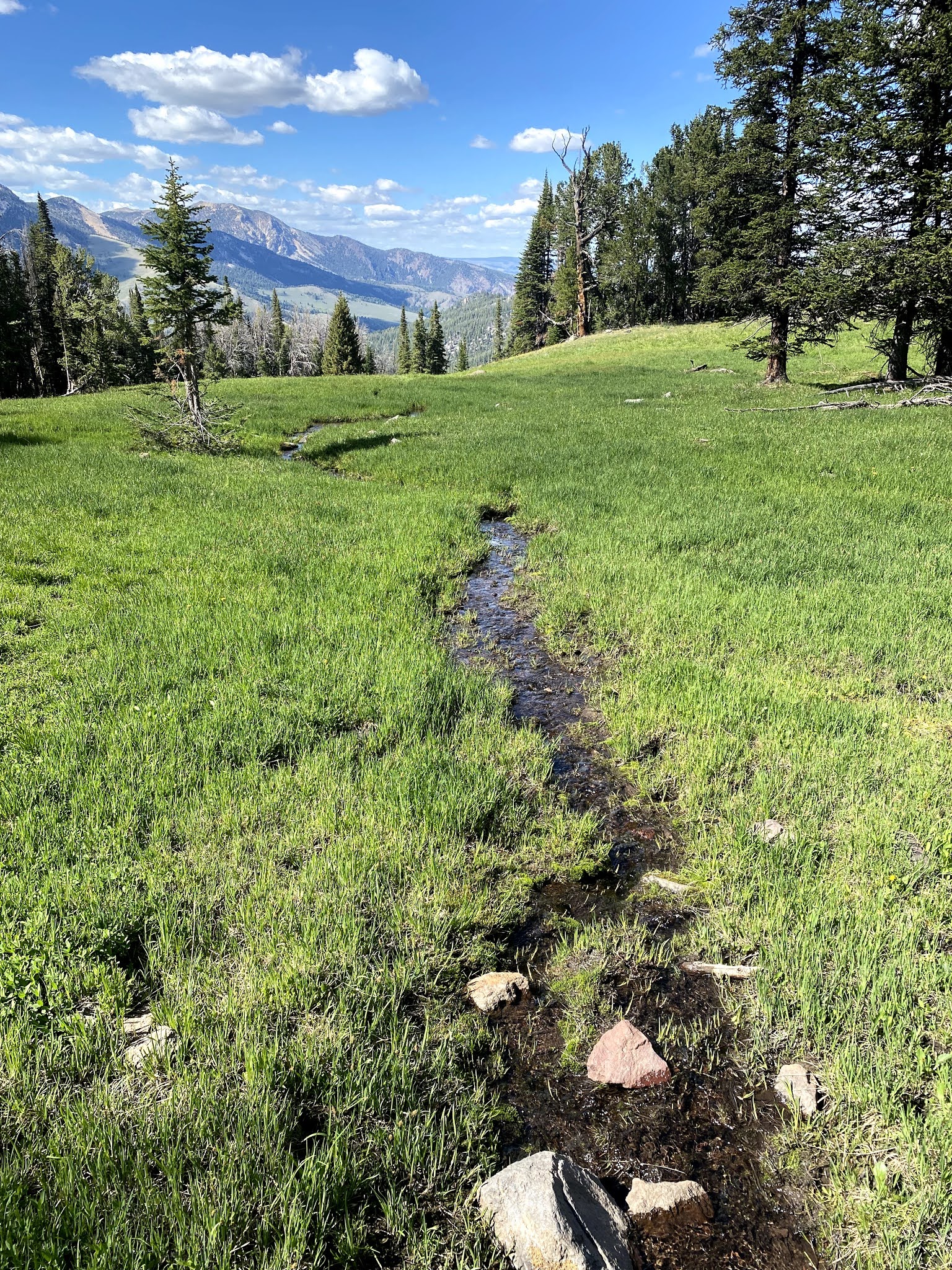
After a short walk along this ridgetop trail, I came to a meadow that had been identified in the book as a possible campsite, as it had a small spring. I decided to camp here near the spring, both for the water and also because the site promised to have amazing views of the night sky and the sunrise. I made camp, got water from the spring (no treatment necessary!), and settled in for the night at "Lemhi Camp 5".
 |
| Lemhi Camp 5, the most perfect campsite of the entire trip. |
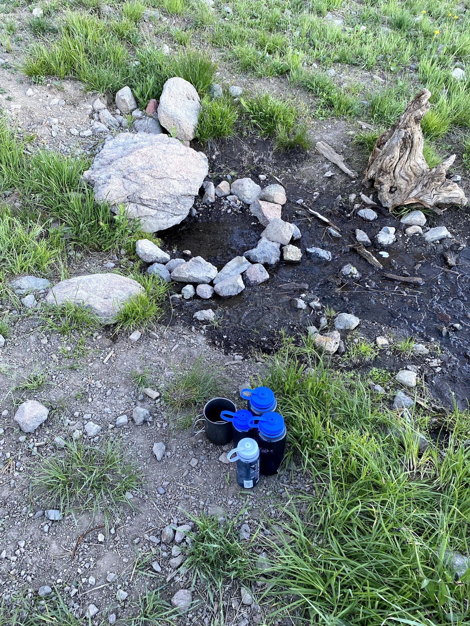 |
| The spring near my camp. Just dip in your cup and taste the ice cold mountain springwater! |
 |
| My campsite in relation to the spring. The views of the night sky and the sunrise promised to be very rewarding. |
Total Miles Walked: 50.77
Daily Miles Walked: 9.54
Highest Altitude: 9260 ft.
==========
27 June 2021.
This morning was as perfect as any morning I've ever had in the mountains. I awoke just before sunrise, as the eastern horizon was beginning to lighten. I sat up in my sleeping bag, put on my long-sleeved hiking shirt, lightweight down jacket (an Eddie Bauer First Ascent, which is an awesome product), my Marmot Precip jacket, and of course a hat on my bald head, tucked the sleeping bag in around my waist, and leaned back against my pack to watch the dawn. I took a series of photos looking first left (east) then right (west) of the progression of the light as the sun came up. It was very peaceful and beautiful, and exactly the kind of thing I came here to experience. If someone were to ask me "Why do you do this?", moments like these would be my answer.
 |
| The view to the eastern horizon almost immediately after I awoke. |
 |
| The view directly ahead of me - facing about SSW. Several elk are grazing in the distance, just to the right of the trees immediately in front of the foot of my sleeping bag. I watched them through binoculars. |
 |
| The view to my right. Watch the peak at left center as the sun continues to rise. |
 |
| A few minutes later. |
 |
| The sun is starting to hit the peaks in the distance. |
 |
| The first glimmer of sun over the mountains. |
 |
| The sunlight is starting to reach the meadow in the distance. |
 |
| Soon I'll be in sunlight myself. |
 |
| The sun has risen. |
 |
| The first rays touch my sleeping bag. Now the dew will begin to evaporate. |
 |
| Moments later, sunlight is quickly spreading across the entire meadow. Time to put away the camera and make breakfast. |
I made breakfast and packed up to go.
That seems a rather abrupt description, so perhaps a word about breakfast is in order. My backpacking breakfast consists of a cup of dried milk, reconstituted inside of a pint Nalgene water bottle. I add three scoops of banana-flavored protein powder and shake thoroughly. Then I add a cup of Quaker Oats "Simply Granola", shake it again, and set it aside. I heat a pint (or a half liter, you pick which) of water and make a mug of spice tea. My recipe for spice tea is very simple - 1/3 Tang, 1/3 instant tea, and 1/3 sugar. I mix the powder at home and carry it in the Tang container. A few spoonfuls of this in a pint of hot water makes a very invigorating breakfast drink. I sat and sipped this in my bag while I continued to savor the morning.
After finishing the spice tea, I heated another pint of water for instant coffee, which I drink black. When the coffee was made I decided the bag was dry enough to pack, so I got up and broke camp while drinking the coffee. By the time it was done, the granola was sufficiently softened to drink the mixture from the bottle, shaking frequently and then using a spoon to get the last bits out of the bottom. I rinsed the bottle, packed the days' ration of hiking snacks (one 4 oz. bar of Romney's Kendal Mintcake {brown variety}, and four links of Bavarian Meats "Lil Landjäger" sausages), and set off.
The ridgetop trail continued for a couple of miles, with beautiful views in all directions. After this it descended a bit and continued on the western side of the ridge, then across into forested slopes on the eastern side for several miles. In addition to scenic photos, I decided to stop and take a few photos of some of the wildflowers that were present everywhere along my way.
 |
| This view of the trail ahead inspired me to start singing "The Road Goes Ever On and On" from LOTR. |
 |
| The mountains overlooking the South Fork Big Creek drainage, down which I would be walking the next day. |
 |
| I think I was looking north-northwest when I took this one. |
 |
| Throughout the day I came closer and closer to this red mountain that I had seen from my campsite. |
 |
| My one and only selfie. I couldn't get the camera to focus on me when using the self-timer. |
 |
| Wildflowers were blooming almost everywhere, but they don't often show up in the photos of distant mountain scenery. |
 |
| Spreading Phlox (Phlox diffusa) |
 |
| Scarlet Gilea (Ipomopsis aggregata) |
 |
| Not sure what this one is. Buehler? Anyone? |
This was one of the days when there were several miles of pleasant hiking, with good trails on which I didn't have to keep my head down and watch where I placed every step. For several days the words of an old walking song had been bouncing around inside my head, and I began to make a concerted effort to remember all the verses. It took awhile, but I finally managed to dredge them all up from the depths of memory, and to sing as I walked along. I meant to type the words into a MapShare message in the evening, but I ended up being too tired. So I'll do it here, as a matter of record. Also for the record, I am *not* looking this up on Google or anything to check the accuracy of my memory. This is how it is etched into my brain, and this is how it will stay:
Upon the hearth the fire is red,
Beneath the roof there is a bed.
But not yet weary are our feet,
Still 'round the corner we may meet
A sudden tree or standing stone
That none have seen but we alone.
Tree and flower, leaf and grass,
Let them pass, let them pass.
Hill and water under sky,
Pass them by, pass them by.
Still round the corner there may wait
A new road or a secret gate.
And though we pass them by today,
Tomorrow we may come this way
And take the hidden paths that run
West towards the moon, east to the sun.
Apple, thorn, nut and sloe,
Let them go, let them go.
Sand and stone and pool and dell
Fare you well, fare you well!
Home is behind, the world ahead,
And there are many paths to tread.
Through shadows to the edge of night
Until the stars are all alight.
Then world behind and home ahead,
We'll wander back to home and bed.
Mist and twilight, cloud and shade,
Away shall fade, away shall fade.
Then fire and lamp, and meat and bread,
And then to bed, and then to bed!
("And now to bed! And now to bed! cried Pippin...").
OK, I had to go look it up after all (LOTR, p. 86-87). I was close, but not quite exact. Not bad for a memory from 45 years ago!
After a long day's hike, I finally came to the four-way trail junction near which I was hoping to make camp. I had begun watching the streams on the map as I passed them, as I didn't want to carry too much water (“a pint’s a pound the world around”) but I also didn't want to have to backtrack for water if I arrived to find the creek at the trail junction to be dry. All but two of the streams shown on the map had running water as I passed them, so I pressed on, deciding it was worth the gamble to carry less weight and arrive at the intersection almost out of water.
 |
| The four-way trail junction with the Iron Creek Trail. |
 |
| Running water! No need to backtrack or make the descent to Iron Creek. |
This area was less than ideal for a campsite, but I was done for the day and didn't want to have to fill up on water and lug it along looking for a better place. Besides that, from here my route was to go straight into a steep climb up over another pass. So this was it. I hunted around for awhile and finally found the least-worst almost-sort-of-flat place to sleep. “Lemhi Camp 6” was next to a tree, transverse to the slope, so that if I did slide downhill, I'd wind up resting against the tree. In the end it worked exactly that way (not for the first time in my life, nor the last, I imagine).
Total Miles Walked: 66.27
Daily Miles Walked: 15.5
Final Altitude: 8705 ft.
==========
28 June 2021.
Today would be my second-to-last day on the trail. I'd start by climbing over an unnamed pass near Iron Creek Point, then descending down the South Fork Big Creek Drainage. This trail would lead all the way back to the trailhead, but I was pretty sure it was too far for me to try to go in one day. I planned to camp somewhere along the way, ideally at a campsite identified in my book that sounded very inviting.
The initial climb was relatively short but vigorous. I ended up in a high, arid meadow where the trail simply petered out and disappeared.
 |
| The view back towards Iron Creek and the trail junction. |
 |
| The trail down towards South Fork Big Creek. I didn't realize it when I took the photo, but the trail peters out and disappears just about where it seems to disappear in the picture. |
I stopped and studied the map for awhile, then started a back-and-forth sweep in the area where I expected the trail to continue down the mountain. After awhile I picked it up, and kept going. The trail continued through beautiful mountain meadows that were very green and lush with springs popping up and brooks running through them. For the first time on the trip I resented the motorcycles, as there were tracks all over some of these meadows, really tearing them up. They are fragile ecosystems and slow to recover, so such conduct is not cool, even if trail riding is allowed. Later, I learned that this trail was closed to motorcycle traffic. So the ignorant bubba who did this is properly to be condemned as an idiot. Like the slob hunter who shoots at road signs, one ignoramus gives everyone a bad name. In spite of this, the overwhelming impression was of pristine beauty.
 |
| These mountain meadows that form the headwaters of the larger creeks are fragile ecosystems. |
 |
| It didn't take long for the trail to rise above the creek and follow along high above it. |
Even though the trail was dry, I was within sight and sound of running water, which was pleasant. (This is the site of another missing video - I hope I can figure out how to post them properly so they are viewable).
This was a very long, sustained downhill hike that was once again hard on my feet, knees, and thighs. By the time I reached the relatively level but still downhill portion that followed the South Fork, I was really ready to stop and camp. In contrast to the previous few days, when the steep terrain had severely limited my options for campsites, this trail had many spots near the creek with level ground that made for very inviting possible campsites. I really wanted to make it to the one I'd chosen in advance, though, because I wanted the next day's hike to the trailhead to be as short as possible so I could drive home afterwards. So I kept going in spite of the temptation to stop.
 |
| Looking south across the valley as I walked west. |
 |
| This section of trail had a lot of easy walking, but by this time I was so tired I hardly enjoyed it - I was ready to be done! |
The trail passed by some impressive rock formations as well. In one place, crossing a loose talus slope, I came to the only spot in the entire trip where the trail made me really nervous - it was so narrow and tenuous that I felt like a mountain goat (it wasn’t even as wide as one boot sole). Had I been able to turn around, I would have, but it was too narrow and I was committed. A slip would have sent me sliding down a very steep, loose slope and into the waters of the creek below, which looked deep and fast enough that I would not have wanted to fall in wearing a backpack. Two or three careful, deliberate steps with a well-planted walking stick for support got me past that section, and I continued on, hoping that would be the only place like that that I'd run into.
 |
| One of the rock formations with a talus slope underneath. Sometimes I had to cross these slopes on rather tenuous trails. |
Finally I came to the desired campsite at about 2130, just in time to get set up before darkness fell. It was a beautiful site, and well worth getting to for the night. I made camp, made dinner, and turned in for a good night's rest. It's worth recording that I was so tired that I fell asleep while treating my water with the Steripen, and dropped it into a 1 liter Nalgene bottle (normally you hold it and stir with it). It kept functioning without shorting out, so I guess it's waterproof, lol! I was glad that I had the little rubber stopper firmly inserted into the charging port.
Total Miles Walked: 80.72
Daily Miles Walked: 14.45
Highest Altitude: 9123 ft.
==========
29 June 2021.
Today's hike would be fairly short, ending at the trailhead and the Jeep (air conditioning, hooray!). But the map showed that I had to climb about 250 ft in elevation, then lose it, then climb back up again before finally descending to the trailhead. So it would not be an especially easy five miles.
 |
| One of the few times that I stopped to take a photo of an uphill stretch of trail. But it never looks as steep or as daunting in the photo as it felt when I was about to climb it. |
 |
| This was interesting - the first of several animal vertebrae scattered along the trail. |
 |
| This was taken at the top after the first 250-foot climb, looking west. You can see the trail angling up the next slope, where I would have to climb up all over again after losing much of the elevation I had gained walking downhill from here. |
 |
| Looking east back toward where I'd come from, for the last time. This photo was taken from the top of the hill where you could see the trail angling upwards in the previous photo. I had taken that one from the open area at the top center of the hill visible in this photo. |
 |
| Looking west, my first glimpse of the valley down which I had initially driven to approach the trailhead. |
 |
| At the top of the last downhill stretch of trail, with the road into the trailhead and a couple of parked vehicles in view. |
 |
| The sign at the trailhead parking area pointing back up the South Fork. This is where I learned that motorcycles were not allowed on that particular trail. I guess Bubba can't read. |
 |
| Finally! Full circle, back at the Jeep. Alles in Ordnung, ready to head for home! |
Total Miles Walked: 85.73
Daily Miles Walked: 5.01
Final Altitude: 6575 ft.
=========
The drive home was absolutely beautiful. I took U.S. 93 north to Missoula, where I turned west on I-90 for the drive to Coeur d'Alene. The first part of U.S. 93, south of the Montana border, is the "Salmon River Scenic Byway", and goes through some starkly beautiful country along the Salmon River before climbing up to the Continental Divide and into Montana. The whole way home I kept looking off into the mountains and thinking "What's over there? That could be a neat place to explore." I was overwhelmed by the vast and seemingly endless opportunities to get out into wild places here. We certainly picked the right place to retire, and I'll be back out again as soon as I can recover from this trip and get organized for the next one!
Now for the major lessons learned from this trip:
I had been planning to get out backpacking again for a long time. Despite the fact that I am an experienced backpacker, I haven’t been on an extended trip in the mountains for many years. I also have a lot of new equipment that I hadn't yet used (or used much), and so there were a lot of details to work out. During the course of the trip I learned (or re-learned) a hundred little lessons as I fell back into the daily rhythm of walking, navigating, making camp, preparing meals, taking care of myself, and starting it all over again the next day. I also learned a few major lessons, which I am already acting on to make my next trip less arduous and more enjoyable:
1. Take less stuff. My pack was far too heavy, topping out at around 90 lb. when loaded with food, fuel, and a partial load (2 liters) of water. This was OK when I was 21, but not any more. Towards the end of the trip I found myself thinking "this is a manageable pack weight - if I could start out at this weight and go down from there I'd be fine". When I weighed my pack at this "manageable weight", it turned out to be 75 lb. So that's my goal for a starting weight: <= 75 lb.
2. My days of tarp camping are behind me. I love to sleep under the stars, and generally only put up a roof (tarp) if it seriously threatens or starts to rain. But rigging a tarp is like sailing a sailboat - you are constantly adjusting, which requires lots of bending and stooping and scooting around. I am just not that flexible anymore. I'll still sleep under the stars whenever I can, but when conditions require a roof I think it will have to be a tent, for speed and simplicity as well as headroom.
3. From now on I will cook simple one-pot meals that weigh as little as possible. There's no reason to eat as cheaply as I had to when I was 21. Goodbye Minute Rice with bouillon cube/cornstarch gravy, and hello Mountain House freeze-dried dinners!
4. From now on I will stick to designated wilderness areas where only foot traffic is allowed. This multi-use National Forest was open to motorcycles, and they really tear up the trails. This in turn made for some very difficult walking, due to the many loose rocks and damaged sections of trail.
5. Don't start a trip immediately after instructing at a Project Appleseed Shoot. I am always exhausted after one of those, and need a day or so to recover. Instead, this time I got up, drove 300+ miles through mountains to the trailhead, and started walking.
6. Altitude has its effects. I live at 2600 feet, and this trip started at about 6,500 feet and went well over 9,500. I am sure that the thinner air had an effect on my ability to get oxygen to my brain and muscles.
7. Even the most rigorous adherence to personal physical maintenance protocols (changing socks regularly, using rubbing alcohol and foot powder at every rest stop, and putting band-aids or moleskin over the first sign of a hotspot that might develop into a blister) can't compensate for lack of preparation. All my walking up to this trip was on smooth, even ground. The uneven trails eventually took their toll on my feet, especially during the last three days. I need to work harder on conditioning my feet for walking on rough trails.
8. My new lightweight Klymit air mattress is completely useless for backpacking. It got good reviews, and felt great on the floor and on the lawn at home, but in the mountains it did not effectively cushion the lumps, and worse, it was like trying to sleep on a toboggan in the snow - it absolutely *refused* to stay in one place. I resolved to pay the weight penalty and go back to my tried-and-true 3/4 length Thermarest mattress (no link for this one - apparently their product line has moved on from my classic self-inflating pad). This has the added advantage of allowing me to use the accessory chair as a backrest when I cannot use the backpack (e.g. inside the tent). I learned that this was *very* important for me at my moderately advanced age, when my knees and back will simply not permit me to sit cross-legged for any length of time. (When I got home I learned that the weight differential is only +1 lb., less than I had anticipated. Yay!)
I've been acting on these lessons in the days since I returned, and will do better next time.
Mood: Happy
Music: Boston, "Don't Look Back"
posted by Brad @ 19:30
4 comments
![]()
![]()


4 Comments:
Unbelievable Brad. I'm jealous. Yea, I read your whole adventure. I can only imagine what you think about while being alone. Congratulations. It took you a few days to get acclimated and then you distance picked up. Those Trout looked so good. You never mentioned Bobo's name so you probably didn't see any. I saw hundreds of mule deer in the Arizona mountains. Glad you shared and made it back.
Thanks, John. It’s been a long time coming! Maybe after this shakedown cruise, next time I’ll be more focused on writing about my mental state while walking. For the first few days I was so focused on all the little details I hadn’t dealt with for so long that they took most of my attention. But by about the time of that last campsite in the meadow the mechanics had started to become more or less automatic again, and I was able to free up my mind and just let it wander and appreciate the beauty and peacefulness in a deeper way. I think perhaps that’s why it suddenly seemed important to take photos of the wildflowers that day. I’d have a hard time improving on Colin Fletcher in this regard, though. His books (“The Thousand Mile Summer” and “The Man Who Walked Through Time” among others) are classics, and really transport you into his shoes during his walks. I wrote about him and his influence on my life here in a personal eulogy back in 2007.
Wow, what an amazing adventure Brad! Really enjoyed all the photos, and of course reading about all your daily experiences and challenges. I was totally exhausted by the end !😉 Well done you! Know how much you enjoy those adventures and so happy you are able to get back out there and enjoy parts of this wonderful world that so many never get to see... or experience! Look forward to your next one! Take care..be safe!
Thank you for telling your adventure. I learned a great deal. Very well written.
Post a Comment
<< Home