A week in the Selkirk Mountains
Since we moved to Idaho, I have spent as much time as I could exploring its very extensive areas of undeveloped backcountry, including wilderness areas, National Forests, and Bureau of Land Management (BLM) land. Because we live in the Panhandle area of North Idaho, this has always meant some fairly long-distance travel southwards in order to access these areas. This year I decided to spend some time exploring closer to home.
From 14-20 August I traveled through the Selkirk Mountains of North Idaho. I have known they were there and had heard about them, but for some reason had never yet spent any significant amount of time up there. The week turned out to be very interesting, and opened up a host of possibilities for future excursions.
The Selkirks extend well into Washington state and north into Canada, but for this trip I confined myself primarily to the portion of the range that lies in Idaho. It is the wettest mountain range in Idaho, and has areas that are classified as temperate rain forest. According to what I read, the most scenic area is the "Selkirk Crest", the range of peaks that runs north-south just west of US-95 and east of Priest Lake, the third-largest lake in Idaho. The rest of the U.S. portion of the Selkirk range is west of Priest Lake, running into Washington state.
This area falls under the administrative management of several different agencies, including the Kaniksu National Forest (now consolidated under the Idaho Panhandle National Forests), Priest Lake State Forest, Priest Lake State Park and the Idaho Department of Lands (an agency that manages Idaho Trust Endowment lands to help fund public education and other state institutions). Each of these agencies manages the land under their care quite differently, and my trip had some interesting wrinkles as a result.
My primary guides for this trip were my ever-present Idaho Atlas and Gazetteer, the USFS map of the Kaniksu National Forest, and the book Trails of the Wild Selkirks. I would have loved to have had the BLM 1:100,000 scale topographic maps of the area (Sandpoint and Bonner's Ferry), but unfortunately they were out of stock at the time I tried to order them. I also learned while writing this paragraph that the book referenced above has been updated - my copy was the 2014 Second Edition. So although it was helpful, some of the information was definitely out of date. Now I understand at least some of the inconsistencies! (And have already ordered an updated copy for future use).
As it turned out, once I had found my way to the general area, the National Forest Map and the subscription iPhone map in OnX Backcountry Elite were the most helpful in navigating away from the main roads. OnX provides the most up-to-date information and is very useful for near-distance route finding and confirming location. But for longer-range planning, I still prefer the paper map - the iPhone just doesn't give the high-level overview necessary for looking several miles or days ahead.
Wednesday 14 August
After my traditional farewell breakfast with Teresa, I headed north on US-95 at about 1200 towards Sandpoint, then continued onwards to Bonner's Ferry. As I approached Bonner's Ferry, I was greeted by an unusual billboard:
 |
| No doubt about where I am. |
When I mentioned this very large billboard to a gas station attendant in Bonner's Ferry, he said "There's a story behind that sign", and proceeded to tell me. Apparently when the current owner bought the property, the billboard was already there, but was blank. He wanted to remove it, but found that it was owned by a third party who had a contractual right to leave it there but had not been using it. Unable remove it, he decided to put up the "Trump Country" sign and see what happened. So far, nothing from the billboard's owner, and if anyone complains, he just says "Sorry, it's not my billboard." 😂
After fueling up in Bonner's Ferry, I took a brief walk through downtown just to see what it was like. I saw three bicyclists sitting at an outdoor cafe, and asked them about the maps they were using. Detecting an accent, I asked where they were from. One of them replied "Germany", to which I replied "Ehrlich! Woher? (Really! Where from?), to which they replied "Munich". I told them I'd been an exchange student in Munich in high school (Max Born Gymnasium in Unterpfaffenhofen-Germering). We had a nice conversation for a few minutes. They had come from Calgary, and were on their way to the Pacific coast and from there south. Quite an adventure! I wished them "Schöne Reise" und "Viel Vergnügen", and we parted company in opposite directions.
I continued on, intending to drive to the northernmost access roads into the mountains from the east, and then gradually work my way south. Along the way, I was amused to see this banner posted by a private driveway off the main road:
 |
| Off Grid Doc - visit us at OffGridDoc.com... 😂 |
I missed my turn off US-95 and found myself at the Canadian border, from where I turned around and went back south about 18 miles to Idaho Highway 1, my intended turnoff west into the mountains. As it turned out this was a good thing, because on the way back south I saw these informational historic markers. The afternoon sun made them difficult to photograph, but they are still legible.


This time I found my turnoff with no trouble, and headed west into the mountains. The Kootenai River runs north-south through a wide valley east of the Selkirk Crest. I don't know what all crops they grow there, but one of the major ones is hops (for beer).
 |
| This beached boat reminded me of the SS Minnow (IYKYK) |
Soon after crossing the Kootenai River I entered an area managed by yet another collection of entities and agencies.
 |
| I think it's neat that so many different groups can cooperate to help preserve natural resources and recreational opportunities. |
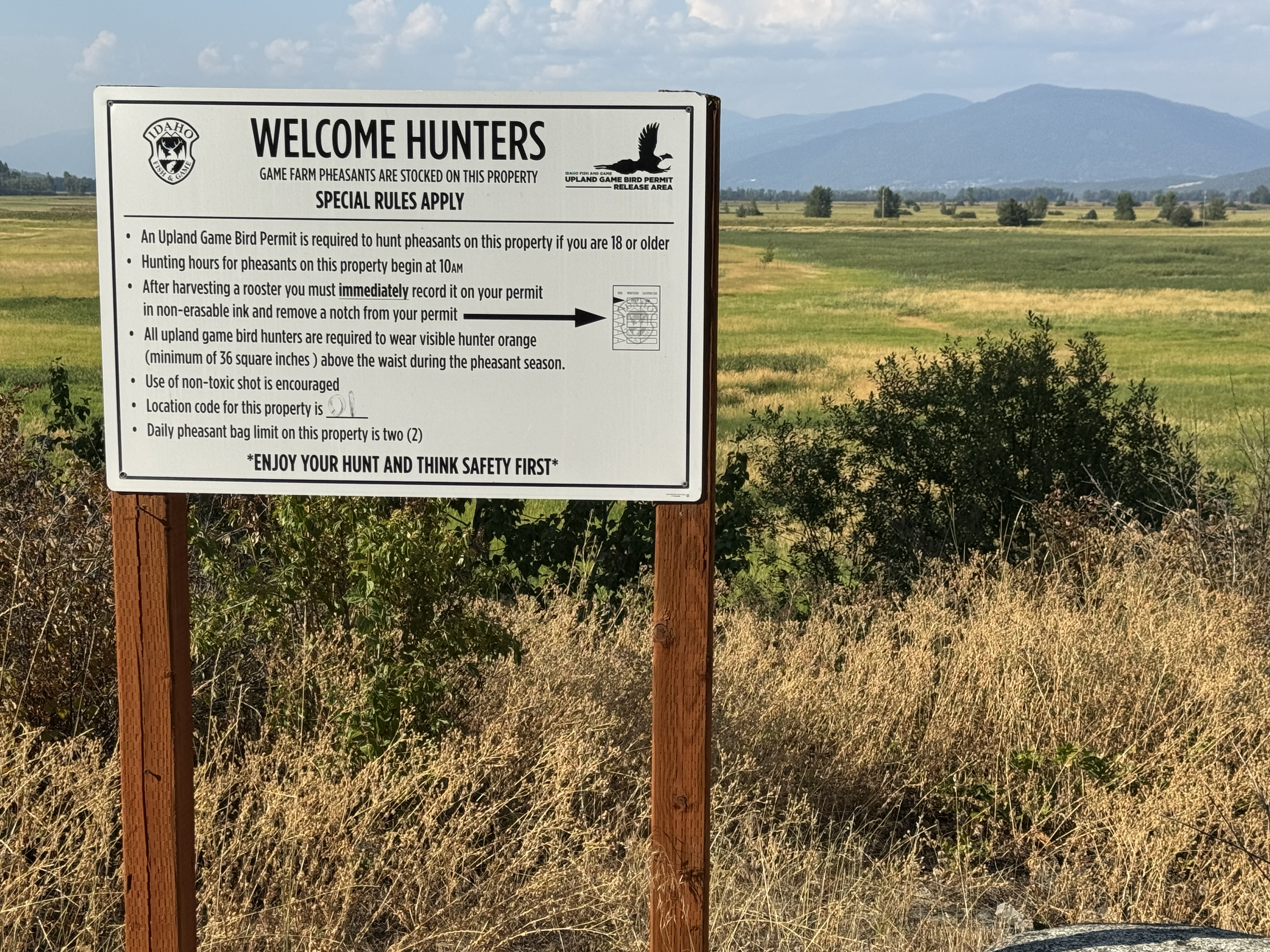 |
| I am not much of a shotgunner and have never hunted birds, but I understand that it's challenging and fun. |
 |
| I don't think I've ever run across a facility quite like this. |
 |
| The road continued from the parking area down to a gated facility. |
 |
| This plaque explains the hydroelectric installation. |
 |
| This notice posted in the parking lot made me feel sad and thoughtful. |
I continued on up the road, heading toward the trailhead to Hidden Lake. There were numerous turnoffs onto other side roads, but I decided to investigate the trailhead first, then consider where to set up camp. The trailhead had room for perhaps a half dozen cars at the most. It was already occupied by one truck. The book said it was a very popular "family fun" (read "easy") hike, so I wasn't surprised to see a car there even mid-week. I *was* a bit surprised by the agency to which it belonged, and wondered if it was there for business or pleasure.
 |
| This was far enough from the border that I'm pretty sure this was just somebody using his work truck to take a pleasure hike. But who knows? |
I backtracked down the road a little way and turned downhill onto a partially-overgrown two-track road that seemed likely to lead to a possible campsite. About a quarter mile into the forest, I came to a nice clearing that was just perfect - unfortunately, it was already occupied.
 |
| My prospective campsite was already occupied by a small herd of cattle. |
 |
| The cattle were completely unfazed by my Jeep, even when I honked the horn and yelled at them out the window. |
There are many places in Idaho's National Forests where cattle are allowed to free-graze, and I had passed other cattle on the way up so this was not a complete surprise. I did wonder how they had gotten this high, though, because I had also crossed several cattle guards on the road, and thought I was past the area where they were supposed to be. I decided that whether they were supposed to be here or not, I needed the clearing more than they did, so I turned my Jeep around, positioned it close to where I thought I'd camp, and got out to chase them away. Loud exclamations of "HYAAH!" accompanied by vigorous waving of my arms had some effect, but they were very reluctant to leave. They would run off into the woods, but then immediately return as soon as I walked away.
I started picking up fist-sized rocks and then charging directly at them shouting "GET OUT OF HERE!", and throwing the rocks at their midsections as hard as I could. The rocks made a very satisfying "thump" when they connected, and had a more lasting effect than just shouting and waving my arms. They finally got the message and moved off further into the woods. They were not happy about having been displaced from their little patch of grass, and their loud, plaintive cries of "MOO-OO!" continued all through the evening until dark, when they finally quieted down.
I set up my campsite in the usual pattern. I now have this down to a very consistent system, so that it takes me less than 30 minutes to be completely set up, and just a little longer than this if I need to put up some kind of a roof. I have now started taking both the Roadhouse Tarp and the Slumber Shack tent on all my trips, so that I can be flexible in response to the weather. But I still prefer to set up in the open whenever rain seems unlikely. It was fairly late and I was pretty tired by the time I got set up, so I had an easy dinner of canned beef stew, sat with a drink reading for awhile, and went to bed under the stars.
 |
| One change on this trip is that I went back to my two-burner Coleman stove. It leaves less work space on the table, but is much more efficient and economical than the cartridge stoves I had been using recently. |
Thursday 15 August
I spent a somewhat restless night, probably because I had finished up my thermos of coffee while making dinner. But there are worse ways to spend a restless night than sleeping under a clear sky filled with brilliant stars. I was able to see the planets Mars, Jupiter, Saturn, Uranus, and Neptune, although I took Mars on faith since my app showed that it was either in front of or behind Jupiter from my perspective. I also saw the constellations Ursa Major (and Minor), Cassiopeia, Orion, Pegasus, and a couple of others I couldn't remember to write down in the morning. The night was cool but not too cold, with a very heavy dew. I awoke at 0500, and it didn't take me very long to decide that I needed a day of rest and would just stay here for a day before moving on. I enjoyed a long, lazy morning doing a few small maintenance and repair chores but mostly just relaxing.
Sometime during the day, I heard a bird calling and thought "that sounds like a jay". Soon I caught sight of a bird in a tree across the clearing. As I stood up to reach for my binoculars, it darted out of sight into the trees. I could still hear it calling, and as it flew in and out of the trees I got some photos. I didn't recognize it at the time, but subsequently looked it up and found that it was a Canada Jay.
 |
| Jays are notorious camp robbers, so I was careful about setting things down while this one was in the neighborhood. |
Later in the morning, I set up my portable sun shade and put out some steel spinner targets to shoot at. I had brought along my little Ruger SP101 .22LR revolver to practice with. The SP101 is a very solid, well-made double action revolver. The .22LR version has a 4.2" barrel and an eight-shot cylinder. It is very handy and light, but I never enjoyed shooting it much because the trigger seemed a bit too heavy compared to my Ruger Old Model Single Six. I've shot many hundreds (thousands?) of rounds through the latter revolver, including several years of competition at my club in Michigan. It was so accurate and so much fun to shoot that it was hard to think of taking a different .22LR revolver to the field. But the SP101 appealed to me because it is very similar to my Bicentennial edition Security Six in .357 Magnum, and I thought it would make a good platform for inexpensive practice.
Over the course of this trip I fired something like 500-600 rounds through the SP101. I soon found that the trigger had smoothed out considerably, and I was able to fire it well in both single- and double-action modes, keeping the spinners in motion fairly consistently at distances from 7-18 yards. It just needed some more breaking in than I had given it up to that point. I carried it cross-draw in an old S&W Model 21-04 leather holster that I had rescued from the bargain bin at my favorite local gun store. Also on that old leather belt is a top-opening .22LR cartridge pouch from Uncle Mike's that holds one box of .22LR for fast and easy reloading. I've had that pouch for at least 30 years but it seems to be out of production, so here's something that looks almost identical: a Crosman Pellet Pouch. The whole rig fits easily over the standard military web belt on which I carry my Kimber Camp Guard 10mm. I am confident that it will now be a very consistent companion on my future camping trips - it's way too much fun to leave at home!
After a relaxing afternoon in camp alternately shooting and reading, I started thinking about where to go the following day. I decided to go ahead and hike up to Hidden Lake and beyond there to Red Top mountain, from which there was supposed to be a beautiful view of the surrounding mountains. I spent part of the evening preparing my pack for the hike. It began to look like rain, so before I went to bed I put up my Roadhouse Tarp just in case. Sure enough, it started raining about 1945. It was a comforting feeling to go to sleep with the sound of rain on the tarp, while remaining warm and dry underneath.
Friday 16 August
I awoke at 0600 after a good night's sleep. The forecast called for thunderstorms, so I decided it was not a good day to hike up a mountain. It wasn't too hard to convince myself to spend a day in camp, as I was still enjoying just relaxing. At about 0930 it began to rain in earnest, so I was glad to have stayed put.
I spent the better part of the morning reorganizing my backpack, asking myself whether each piece of equipment was really necessary for an overnight. I am very prone to "I'll take it just in case" syndrome, and my pack is usually too heavy as a result. I got it to where I felt comfortable and set it aside for the next day's hike. The rest of my day was spent mostly under the roof, alternately reading and doing some target practice. It cooled down considerably with the change in weather, and I put on Smartwool 150 top and bottom to conserve heat, as I was pretty sedentary all day.
Partway through the day, the wind picked up and began blowing rain into the back of my shelter, which was open to the west. I had brought along an old backpacking tarp with the intention of using it to extend the protected "porch" area of the Slumbershack, but it turned out to be equally useful in creating a wind/weather break for the tarp. No more target practice out the back door, however!
 |
| My old backpacking tarp made a good extension to keep out the wind-driven rain. |
I decided that a day sitting under the tarp in the rain merited a steak dinner, so I grilled a steak for dinner and spent the remainder of the evening reading.
Saturday 17 August
This was a long, eventful day. After breakfast, I packed everything up in the Jeep, expecting to hike up to Hidden Lake and then beyond to Red Top Mountain. I didn't mind leaving the Jeep there, but I didn't want to leave everything set up in the campsite. I figured that when I returned, I would probably just get in the Jeep and drive off to find a new place, since I'd already been here for two nights. When everything was just about packed up, I turned on the Jeep for some reason and was surprised when all it made was a strange clicking noise for awhile, then nothing. DUH! I couldn't believe I had not thought of it, but for two full days and nights in camp, I had not started the Jeep at all. Using the lights and charging the iPhone, the iPad, and the Thermacell had depleted the battery far more than I expected, and it was stone dead.
I couldn't leave with it in that state, so I unpacked enough to get out my emergency car starter battery pack, hoping that it would be as simple as that. Fortunately that was all it was, so once the Jeep was started, I sat and let it run for about an hour. I had learned recently that it takes about 20 minutes of running the alternator to recharge the battery back up from one instance of starting the engine. I wanted to make sure it had a good charge, and also to recharge the emergency battery, which holds enough power for about two engine starts. I was not about to turn off the Jeep until that was fully charged again!
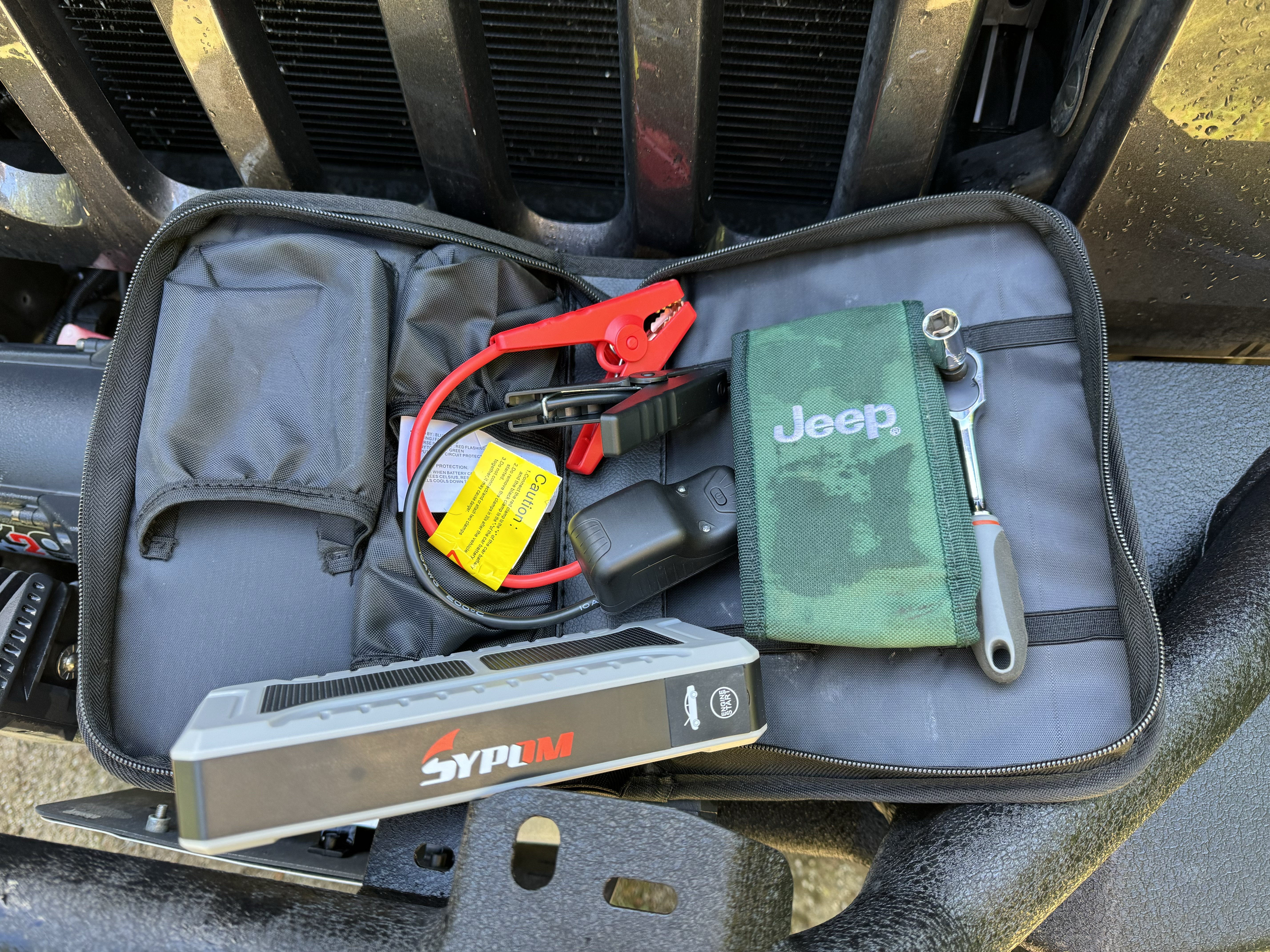 |
| The little green tool kit that came with the Jeep has a ratchet and several Torx heads for the hardtop and soft top. I always wondered why it also came with a socket. Now I know - it fits the battery terminals. |
 |
| I came to Priest Lake fairly late in the day. It is beautiful, and not hard to understand why it is a popular destination. I had a hard time getting a photo that didn't have boats in it. |
Close examination of the map combined with the guidebook led me to pick a road to travel up into the mountains that would get me someplace near "Lookout Mountain", a promising location for a day hike. By this time I was in the Priest Lake State Forest, shown in purple on my USFS map (vs. green for National Forest lands). As I drove up the road I had selected, three things surprised me. One was that almost every side road leading off of the "main" road (not really much of a road) was deliberately blocked off with large boulders. The second was the number of areas that had been clear-cut by loggers. The third was that despite the fact that it was as out-of-the-way a route as I could pick off of the map, a really astonishing number of cars and trucks were going in both directions. Because it was late in the day, most were going out, but several were also traveling in the same direction I was. I thought perhaps they were picking huckleberries, as this was the height of the season. I began to despair of finding anyplace to camp, as there was simply no place to turn off.
I finally decided to try the road/Jeep trail that the map showed leading up to Lookout Mountain. Although it too was blocked by boulders, it looked as though I might be able to squeeze through between two of them if I was very careful. Creeping up the very rough track in low range, I held my breath waiting for the *SCREEEECH* of stone on metal, but it never came. Once through the boulder blockade, it was a rough crawl uphill for a few hundred feet until I got around a corner and out of sight. I found a sort-of flattish area, and since it was getting dark I decided this would be my camp.
I turned the Jeep around, and set up camp directly by the Jeep trail. It didn't feel like rain so I didn't bother with a roof. It wasn't really very level, so I had to use a shovel to dig out places for the uphill legs of my cot so that I wouldn't spend the night sliding downhill. Every time I got up, I had to make sure of my footing and my balance before trying to do anything. It was not my most optimal campsite, but I made it work. It was a beautiful clear night, and once again I enjoyed identifying some constellations (Hercules, Sagittarius, Lyra, and Cygnus) and watching for shooting stars and satellites.
Sunday, 18 August
I woke up at 0500 but lazed in bed until 0545, then made a hearty breakfast of eggs and corned beef hash. I decided to pack up the Jeep and prepare my day pack, then decide whether to hike up Lookout Mountain. The Jeep trail that I had camped on was the old access road up to the top. It was not the trail described in the guidebook - the access road was on the south side of the mountain, but the approach road to the trailhead as well as most of the trail were on the west side. According to the map, the two merged just below the summit. A closer examination of the map decided the issue - the summit with the old lookout is at 6,727 ft. altitude, and my camp was at 3,350 ft. The official trailhead was shown at 5,320 ft., meaning it would be a 1,400 ft. climb from there vs. 3,400 ft. from where I was. Easy decision! I started the Jeep and headed back down the mountain about 1045.
Once again, I was astonished at how many cars were headed up this rough and remote road. While easing past one of them at a wide spot in the road, I asked them where everybody was going. They told me there was a "natural water slide" up the hill about a mile or two, and they were headed there. Later on, when I stopped in at the Priest Lake State Park to use a restroom and confirm that I didn't have to pay a fee to use the park, the ranger there told me (rather regretfully) that there were some natural rock formations with water running down them, and that "someone put it on the internet and spoiled it - now it's overrun with people". So much for my having picked a remote location off the map!
This is the first time I had ever used a state park in Idaho, and there were signs all over the place that said "Fee Area", with warnings about how they checked and enforced the fees. I have a veteran's pass but I wasn't sure what what it covered and what it did not. When I asked the rangers about it, they acted as though they'd never seen one before, and weren't sure what to do or whether I was supposed to display it in the window. They suggested that I put it on the dashboard in case a ranger went by while I was parked someplace, which seemed reasonable to me.
 |
| If mine is only #1273, perhaps it's not surprising they hadn't seen one before. |
As I drove through the campground, I marveled at how people could go to all the trouble to come here and "camp". It was a winding asphalt road, with short paved drives turning off to campsites on both sides. It was shaded by trees but had very little undergrowth. I passed campsite after campsite, with people sitting in chairs and at picnic tables or cooking and doing other camp chores, all within yards of the road and each other. The campsites were closer together than houses in the average suburban neighborhood! It was bizarre. I thought perhaps people feel the need for the security of others close around them or something. (I also wondered if this is what people think of when they hear that I am going camping, lol.)
After passing through the campground, I drove through the parking lot of a beach on Priest Lake, and it was then that I got a sense of why people might want to come here. It was a nice, broad sandy beach, with restrooms and other amenities. People were swimming, sunbathing, playing in the sand - all the kinds of things you'd expect to see at a beach, and all within walking distance of the campground. So for a family weekend letting the kids play in the sand and swim, and perhaps taking a scenic drive or a hike, I could better understand the attraction. But it sure isn't an attraction for me!
I continued on out of the park and through the Priest Lake State Forest. The roads there are not nearly as well-marked as they are on National Forest lands. This is consistent with the fact that while they are open to the public, recreational use is only secondary - their primary purpose is to generate revenue for the state of Idaho. I passed numerous logging operations and areas where the forest had been clear-cut, with piles of logs awaiting pickup.
 |
| Some heavy equipment operator had a sense of humor. 🙂 |
 |
| Logs awaiting pickup. |
 |
| I saw some beautiful views on the way up to the trailhead, but the best was yet to come. |
I drove up the mountain as far as possible until the road ended. There was a perfect place to back my Jeep in to camp, and I could see where the trail headed off into the woods. I was kind of surprised that there were no directional signs or any indication that this was the trail to Lookout Mountain, but I was confident in my location and proceeded to set up camp. While I was setting up my camp, I was surprised when four people came walking out of the woods headed uphill past me. As it turned out, the actual trailhead was down below (where I later saw a partially-obscured sign pointing to the trail). We talked for a few minutes, and the they headed down the trail to Lookout Lake, beyond which our guidebook (they had the same one) said the trail continued up the mountain to the lookout. There was another trail from where I was camped that headed off eastward, but no indication of where it might lead.
I finished setting up camp, and since it was getting late in the day and there were already people on the trail, I decided to relax for the afternoon and wait to hike up until the next morning, when it would be cooler and I'd have a head start on anyone else who might want to come. Since the following day was Monday, the likelihood that I'd be alone would be substantially improved.
After a couple of hours, the people came walking back by. They reported that the lake was an easy hike down the trail, but that they'd been completely unable to find any trail from there up to the summit. Apparently the guidebook was wrong or the trail had changed. They had brief discussion among themselves about whether to take the other trail, but since it was late in the day and hot, they decided to hike back down to their car and go home. In contrast to my usual attitude, I was very glad that they had come by, because they had effectively scouted the trail for me, and prevented me from wasting a lot of time. I resolved to skip the lake, and to take the alternative trail in the morning. I spent about an hour picking huckleberries ending up with a full stomach, purple fingertips. and a cupful to take home to Teresa. After a relaxing evening, I went to be about 2130.
 |
| One for Teresa, one for me, one for Teresa, two for me...😋 |
Monday 19 August
The night was clear and cool - just chilly enough to make me appreciate my sleeping bag. I got up at 0545, and after a quick breakfast of oatmeal and toast I cleaned up, broke camp, and packed the Jeep. My plan was to hike up to the lookout, enjoy the view, then come back down and immediately move on and head west around the north end of Priest Lake. This would be my first hike using my new daypack, a Badlands Superday hunting pack. For about fifteen years, I've used a Camelbak day pack that I bought at the PX. It's a pretty good pack, but has a limited capacity, and I've wanted something a little larger. I spent some time looking at various alternatives, and settled on this one for the mix of features, capacity, multiple pockets, and carrying comfort. They also make a very cool binocular case and a set of connector straps to hold it onto the pack. I didn't have this yet, but today's hike with my binoculars bouncing around on my chest would help me to decide to pick one up when I got home.
At 5491 ft. my campsite was a bit higher than the official trailhead, so my hike was effectively already started, lol. It was a pleasant mountain hike on a pretty decent trail through shady woods, switching back from time to time as I climbed the fairly gentle grade. Parts of the trail were dirt, but much of it was rocky. I began to catch fleeting glimpses through the trees of Priest Lake off to the south, a tantalizing preview of the breathtaking views I would see from higher up the mountain.
 |
| A typical mountain trail. |
 |
| Intermittent glimpses hinted at the view from the top. I like the way that the new branches sprouting from the fallen tree grow straight up. |
I didn't keep my normal detailed notes of rest stops and altitudes, but I had started at 0945 and took three rests on the way up. Each time, I was surrounded by huckleberry bushes bursting with ripe berries. It was actually hard to sit down anywhere that *didn't* have huckleberries, and I ended up with purples stains on some of my clothes and gear. But I hardly cared - as I rested and sipped water, I could reach out in every direction and pick handfuls of them without even having to sit up! It was Huckleberry Heaven, lol.
As I got closer to the summit, the trail became steeper and more rocky.
 |
| A Stairway to Heaven. |
 |
| There's more than one flight of stairs, lol. |
The last 400 feet of elevation gain were on the old access road, which for some reason went basically straight up with no switchbacks. It was a steep, heads-down slog for the last leg, with nothing pleasant or redeeming about it except for the relief of finally glimpsing the lookout platform above me when I neared the top.
 |
| OMG, are you f*ing kidding me? |
 |
| Finally! |
 |
| The first thing I did after reaching the summit was to drink down a pint of water with this mixed in. I needed it! |
At the summit there are two lookout structures - the original restored building from 1929, and a larger, taller steel tower from the 1970s. The latter looks like the same design as the one I'd visited on the Magruder Corridor, but in this case the building at the top has been removed, and only the platform remains intact. I sat down in the shade of the platform to eat my lunch before ascending to take in the view.
 |
| This sign was on the third step, and repeated again a bit higher up. I was very, very careful, testing each step before putting my weight on it, making sure I always had a firm grip with both hands before moving a foot to the next step, etc. There were a couple of dicey steps, but mostly it was very solid. I suppose they have to put up warnings like this, but they can hardly expect people to hike all the way up here and not climb up to the observation platform! |
 |
| The view south. The distinctive formation of Chimney Rock is visible along the Selkirk Crest. |
 |
| Looking southwest over Priest Lake. It is slightly smaller than Lake Coeur d'Alene (20 miles long vs. 25), but is much less developed and mostly surrounded by protected public lands. |
 |
| Looking west past Upper Priest Lake into Washington. Note the rectangular clear-cut areas just to the south and east of the lake, as well as to the north. |
 |
| The view to the northwest. |
 |
| Looking north. Many of the mountains visible in the distance are in Canada. |
 |
| Looking northeast past the historic lookout building. |
 |
| Looking east. The third peak from the left is known as the Lion's Head. From this direction, I actually thought the rounded formation just above the center of the photo looked more like a lion's head (see below). |
 |
| This looked more like a lion to me - crouching down, facing to the left, brow furrowed and jaws open. |
 |
| Closing the circle - the view to the southeast. |
In examining the map, I had noticed that the Pacific Northwest National Scenic Trail (PNT) passes right along the same route I had hiked up to the lookout. Now, if you think I'm adventurous, read this account of another person's hike that I found while looking up the Lion's Head. Ahh, to be young again! https://twigadventures.com/pnt-day-15-lions-head/.
 |
| This sign was posted on the door of the old lookout building. I'm grateful that volunteer groups like this take the time and make the effort to preserve such places. |
Although the text is somewhat dated (the lookout is no longer in active use), this site gives an interesting account of the history of fire lookouts in Idaho: Lookout Mountain.
I started back down the mountain towards my Jeep at 1330. I was grateful to have switched from my old walking stick to trekking poles on the steep in initial portion of the descent. I stopped to rest a couple of times on the way down, and got to the point where I literally could not eat another huckleberry (who'd a thunk it?). I reached the Jeep at 1505 and drove off shortly after that.
I drove to the north and west around the north end of Upper Priest Lake, exploring side roads (when they were open). I found myself getting tired, and started looking for a place to camp. I settled on a spot at the end of a short side road, partway up Caribou Hill. I didn't like the fact that my Jeep was visible from the road, but it was about 200 yards away, downhill, and right at a turn in the main road. I didn't imagine that most people driving by (if anyone did) would even glance upwards in my direction. It turned out to be a very rewarding campsite, with a great view to the east and southeast.
 |
| Looking south-southeast from my campsite, the structures on Lookout Mountain are just visible, reflecting the late afternoon sun. |
 |
| I never get tired of open-air campsites with expansive views. My field towel and space blanket "bath mat" are drying off on the bushes. |
 |
| The emergent moonrise was as beautiful as a sunset. |
 |
| The full moon made a great night light. I tried to photograph it, but either the iPhone is not sophisticated enough to take photographs that show the details of the surface, or (more likely) I don't know how to use it properly for this type of photo. |
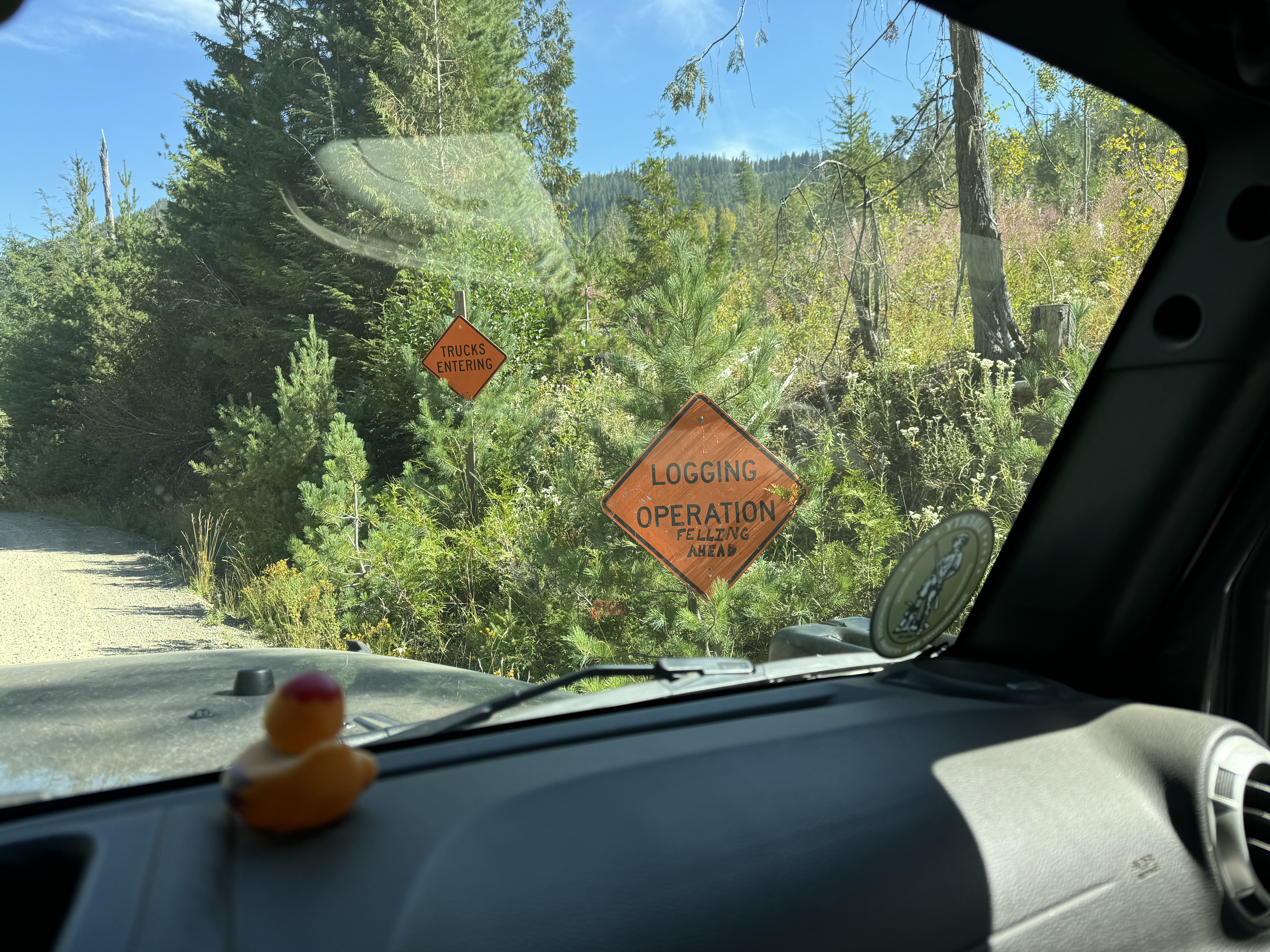 |
| Watch out for falling trees and heavy equipment! |
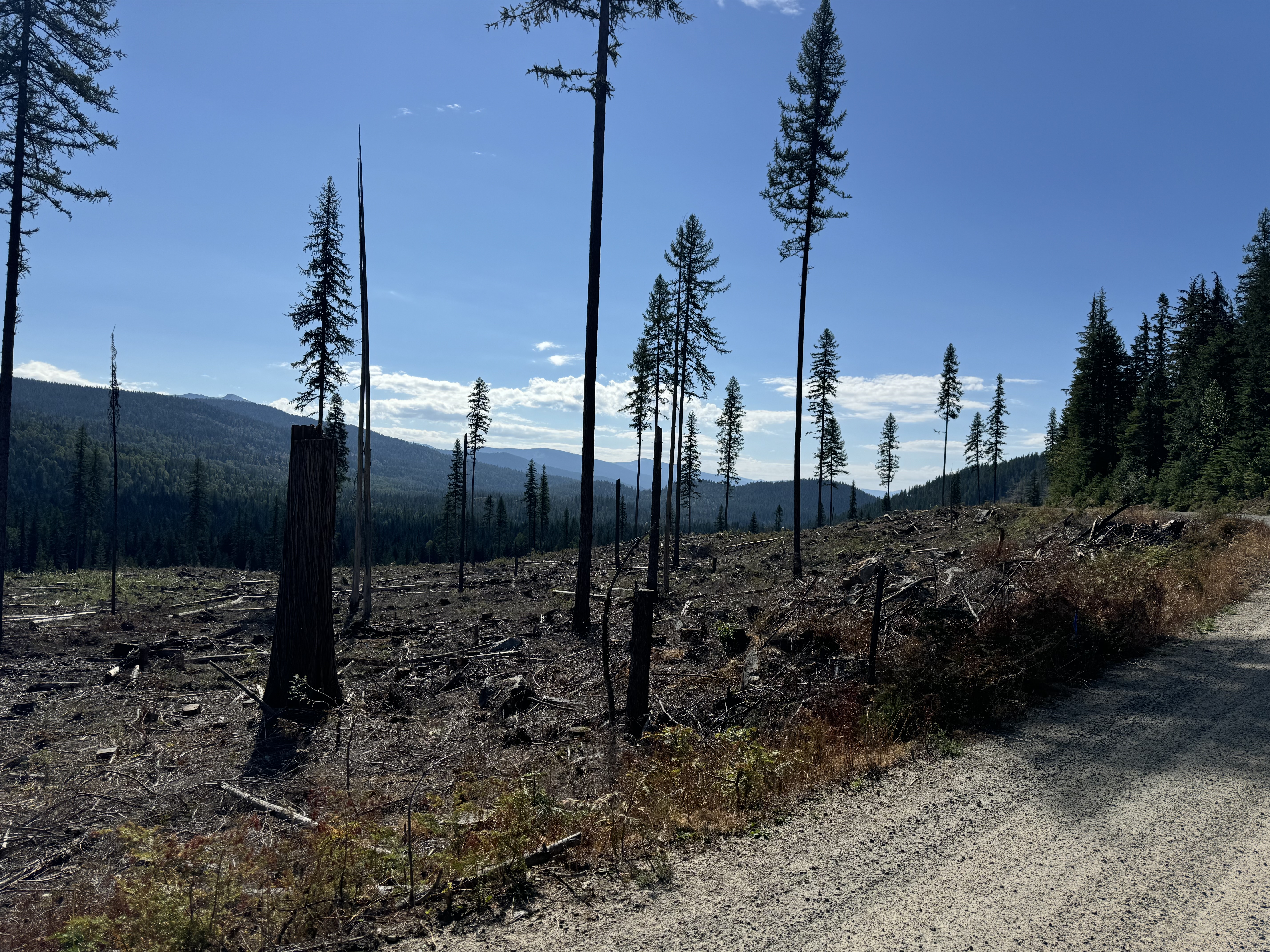 |
| One of the clear-cut areas. I'm not sure why they leave a few trees standing, but they were spaced out at somewhat regular intervals, suggesting a systematic approach for a definite purpose. |
 |
| Considering that it's been logged for at least 74 years, the forest is in pretty good shape. |
 |
| I liked "Christmas Tree Cutting: Two trees per family are allowed without a permit". |
 |
| One of the very few places along this stretch that offered any kind of view. Mostly it was through trees like those in the foreground, overgrown on both sides of the road. It reminded me of the approach drive to the river in the movie "Deliverance". |
 |
| I couldn't get all the piles of logs into one photo. They keep them soaked with water, presumably to minimize the danger of fire. |
 |
| The logs are processed through the sawmill and then go into stacks of finished lumber like this... |
 |
| And finally into shrink-wrapped bundles ready to be loaded onto railcars and shipped across the country. The logo on the side of the bundles says "Idaho Forest Group". |
Mood: Happy
Music: Dueling Banjos 🪕😂
posted by Brad @ 3:31:00 PM
1 comments
![]()
![]()

